Letter to Freedman's Bureau
Source: Virginia Freedman's Bureau Letters 1865-1872
National Archives Record Group 105, Reel #44 Image 349
(Also Family Search Image: #4150377)
(see transcription below)
(see transcription below)
Researching African American ancestry is not without its challenges. The 1870 census provides a glimpse at a community of individuals who were a mere 5 years living in freedom.
But sometimes the assumption is often made that the individuals were living in the communities where they had been enslaved, and had not ventured far from their home.
It possible that in most cases this is true, however, if one studies the thousands of non-indexed pages from NARA Record Group 105--(the Freedman's Bureau) a wealth of data can be found that might reflect stories otherwise not known.
The Haney Family - A Case Study
In 1867 a woman Jane wrote to the Freedman's Bureau office in search of her sons. Upon first glance I would have thought that Jane's sons had been sold away from her, and she was seeking assistance to find them.
However in this case---they did not leave Virginia until 1866. They had signed a contract in Alexandria Virginia to travel to eastern Arkansas, to work for a year, with their father. Meanwhile, in Arkansas, the father of the two boys died after a short illness and their mother was seeking information about their return.
The letter reads:
Alexander Va.
August 16th, 1867
Col. S. P. Lee
Sub. Asst. Commr.
Alexander Virginia
Sir,
I have the honor to apply to you to assist me in procuring my two sons Lewis Haney age 13 yrs, and Joshua Haney aged 16 yrs who are now in the vicinity of Helena Arkansas.
With their father Joshua Haney, they made a , 1866 contract April 16th in your office to work for one year with the firm of Van Belk, & Co., of Helena Arkansas. They remained with Van Belk & Co. until their year expired and were discharged. After this they were employed by Mr. Briant Lynch of St. Francis Co. Ark until the 27th of July last when the father (my husband) died after an illness of nine days. The boys are now without any one to care for them and on account of their age I am anxious to have them under my care and protection.
Source: Virginia Freedman's Bureau Letters 1865-1872
National Archives Record Group 105, Reel #44 Image 350
(Also Family Search Image: #4150377)
(next page)
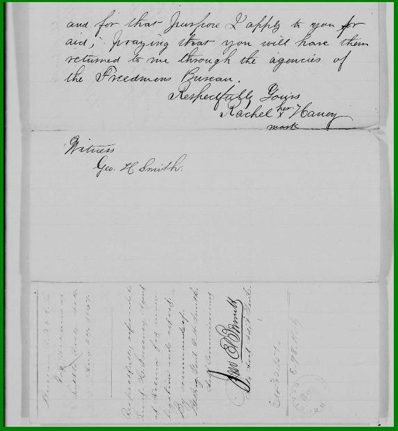
and for that purpose I apply to you for aid, praying that you will have them returned to me through the agencies of the Freedman's Bureau.
Respectfully yours,
Rachel (her X mark) Haney
Witness Geo. H. Smith
* * * * *
Rachel's letter was interesting for several reasons. Was Rachel in search of children who had been sold from her? Not at all!
She lived in Virginia and it appears that a contract was made with the Bureau to provide labor in eastern Arkansas. Upon reading this letter one cannot wonder what the circumstances were that Arkansas needed to send for workers? There were thousands of former slaves along the Mississippi River, and there was a Freedman's Bureau field office in many places in eastern Arkansas to assist with labor contracts.
With there being no shortage of labor in eastern Arkansas, what were the circumstances for the recruitment of workers from Virginia?
There must have been steady communication between Rachel and her family since she was clearly aware of what had happened to her husband as well as the status of her sons, when their contract had ended. This is significant, particularly because this reveals a part of history that is just simply not well known. This tells the story of what happened in those critical years between 1865 and 1870.
In this case---we see that a contract was made to send a large number of former slaves from Virginia to work in Arkansas. This was organized by the Bureau of Refugees, Freedmen and Abandoned Lands---the Freedman's Bureau.
So----what happened to Rachel's children?
A report in the Freedman's Bureau files describes what happened to them.


A report in the Freedman's Bureau files describes what happened to them.

Source: Virginia Freedman's Bureau Letters 1865-1872
National Archives Record Group 105, Reel #44 Image 703
(See transcription below)
Hd Qrs Ass Com Dist of Va
Richmond Va, Oct 4, 1867
Filed:
Respectfully returned to Brt. Lt Col. S.P.Lee S.A.C.inviting attention to understatement of E.G. Barker, Agent.
Madera Ark. Sept 14th, 1867
Respectfully returned to Lieut. H. Sweeney Agt. at Helena Ark. with the information that the children Lewis and Joshua Haney are still with Mr. Bryant Lynch of this County, and who has a contact with them appeared at this office. Their compensation is $9.00 for the oldest and $7.00 for the youngest per month the contract expiring on the 25th day of Dec of 1867. Mr. Lynch is a prominent man in St. Francis Co. and I think is treating the children kindly: they will be looked after by the Bur in this co. and in my opinion would do well to remain until the expiration of their contract.
* * * * *
My question----was this common for persons from Virginia, once enslaved and later freed, to be sent under contract to work in places as distant as Arkansas?
Were there others from the same community sent there as well?
If so---were there many or were they just a small number whose story is mere anecdotal?
Well, further investigation revealed so much more. And the answers were found in the Virginia Freedman's Bureau. Thankfully all of the reels are digitized and one tenacious researcher in Virginia is going through each and every reel, looking for interesting stories to share. (Thank you Selma Stewart!)
In fact----she located the very answers to those questions, including a contract with the names of the Haney children and others from Alexandria Virginia. On reel 52, images 826 - 829 answer those questions. (see image and transcription below)
A signed Article of Agreement in which the Haney children and their father and many others from Alexandria agree to go to Arkansas to go to Arkansas to work, was dated 13th of April 1866. The contract expired on January 1, 1867. It appears that the same Haneys mentioned in the letter by Rachel are her family--Henry, Joshua and Lewis Haney. The wages were $15.00 per month, and Lewis is was stated was to receive $8.00
.

Source: Virginia Freedman's Bureau Letters 1865-1872
National Archives Record Group 105, Reel #52 Image 826
The surprise was to find a list of names of dozens of people including the Haneys who were from Virginia and sent to Arkansas under contract to work, right after the Civil War.

Close up view of contract
Source: Virginia Freedman's Bureau Letters 1865-1872
And a few pages later, came the names of dozens of people.

Partial View and Close Up of document from FB where workers were contracted for Arkansas
Source: Virginia Freedman's Bureau Letters 1865-1872
National Archives Record Group 105, Reel #52 Image 827
Surprisingly more pages of names of former slaves from Alexandria Virginia appeared on following pages!

Source: Virginia Freedman's Bureau Letters 1865-1872
National Archives Record Group 105, Reel #52 Image 828
This particular story had a happy ending----the Haney children returned to Virginia and they are found in the 1870 census in Alexandria Virginia.
The question must be asked however----what of the others? Did they all return to Virginia, leaving Arkansas after their contracts ended?
And what if they stayed?
What are the implications for the genealogist?
One thing is clear---there is a potential for error.
If some of the Virginia people chose to remain in Arkansas, or move elsewhere they won't appear in the Federal census until 1870. Will their origins from Alexandria Virginia be known? Probably not.
If the story of being contracted by the Freedman's Bureau did not survive family oral history---how will the genealogist be able to tell this critical and significant story?
Sandy Nash A Case Study
Let's look at the case of Sandy Nash. His name also appears on the document of former slaves from Alexandria Virginia sent to Helena Arkansas.

Close Up View
Source: Virginia Freedman's Bureau Letters 1865-1872
National Archives Record Group 105, Reel #52 Image 829
Sandy Nash's name appears on line 306.
I searched for Sandy Nash in Virginia and did not find him there and then I decided to see if I could find Sandy Nash in Phillips County Arkansas in 1870 and sure enough---he was right there. He had chosen to remain in the west and not return to Virginia.
Excerpt from 1870 Federal Census Reflecting Sandy Nash
Source: Year: 1870; Census Place: Planters, Phillips, Arkansas;
Roll: M593_60; Page: 63B; Image: 128; Family History Library Film: 545559.
Ancestry.com. 1870 United States Federal Census [database on-line]. Provo, UT, USA:
Ancestry.com Operations, Inc., 2009. Images reproduced by FamilySearch.
Now---if a descendant of Sandy Nash who might still be living in Arkansas, he or she will find Sandy in 1870 in Phillips County.
The researcher---if following the advice of the masters--will look for him in 1860, and then begin the search to find his last slave owner, presumably in Arkansas.
Genealogists are taught-- that after determining that a black person was not free in 1860, then one can start to look for the last slaveholder in the same community.
But in this case----Sandy Nash's last slave holder was in Fairfax county Virginia and was never in Phillips County Arkansas. It is usually recommended to African American researchers that when beginning the search for the last slave owner, that one begins in the community where one finds the former slave.
And if this was not known via oral history---then how will the research ever know where in Virginia to find Sandy Nash?
Chances are---the researcher may hit this brick wall and remain there for years. Even should the researcher turn to Freedman's Bureau records, the first move would be to use the Bureau records from Arkansas. And all of this data came from Virginia!
There are several points that I have learned from the cases above.
1) It is important to share what you find. Had a research colleague living in Virginia not shared this with me, I would never have known about these workers, several hundred----of them being contracted to go to Arkansas to work after the Civil War. She happened to know that Arkansas is one of my states and generously shared it with me.
2) It is important to avoid making assumptions In this case--the researcher might hit a brick wall, unable to find the last slaveholder in the local community. One might have to think outside of the box and ask about other resources that reflect the community and the time period--especially in those critical years after the Civil War. One should not assume that the former slave found in 1870 was a slave in the same place before the war.
3) Utilize all available Reconstruction Era records. In the case of the Haneys, the researcher might find the Haney children in 1870, with little additional information about the family. However, the Freedman's Bureau letters contain a wealth of data found in the letter from their mother telling the story of their being in Arkansas. She mentioned them by name, and also mentioned the name of their father, who died while in Arkansas. If no known death record was known to exist--her letter might be the only piece of data about the father--his name and approximate time of death are in her letter.
We conduct our research because of the love of history and a desire to see that stories are told, and in this case---stories can be found when we least expect them.
Special thanks to Selma Stewart of Newport News Virginia, who in her effort to look at every reel of microfilm that is now digitized, and available on Family Search, she shared the letters to me, and she opened my eyes to new possibilities.